Dublin Road
Dublin Road is the R338, a regional road in Galway, 2.5 km east of Eyre Square. It is 4.5 km long, about 57 minutes on foot end to end. It has 24 named places on the map: 3 convenience stores, 2 gyms, 2 cash machines and 2 nursing homes and more.
- Type
- Regional road (R338)
- Length
- 4.5 km of mapped road
- From Eyre Square
- 2.5 km east
- Joins
- Ballyloughane Road, Belmont, Coast Road, College Road, Doughiska Road, Geata Na Mara, Michael Collins Road, Moneenageisha Road, Renmore Park, Renmore Road, Rosshill Road, Skerritt Roundabout, Wellpark Road, Woodhaven
- Runs
- from College Road
- Bus stops
- Dublin Rd (Woodlands); Dublin Rd (Opp G Hotel); The G Hotel; Unnamed stop; Glenina Heights; Galway (GMIT); Galway (GMIT); Galwegians RFC; Merlin Hospital Gate; Woodhaven; Glenina Heights; Dawn Dairies; Unnamed stop; Unnamed stop; Unnamed stop; Unnamed stop; Líos an Uisce; Renmore Park; Bon Secours Hospl
- Nearest parking
- Clareview Park on Clareview Park, 516 m away
- Density
- 24 named places over 4.5 km, 0.5 per 100 m
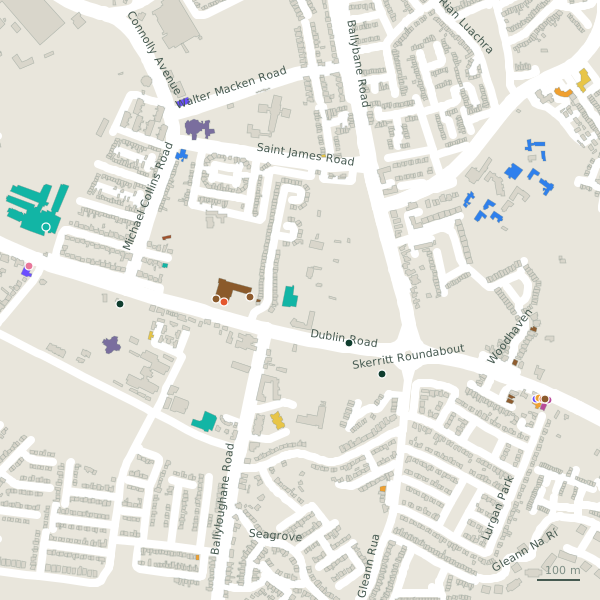
The street is drawn in black; buildings are coloured by what is in them. Drag to turn the model, tap a pin for the place.
Plan of the street
A walk along Dublin Road
Walking its length 3 convenience stores, 2 gyms, 2 cash machines, 2 nursing homes, 2 hotels and 2 pubs and more share the 4.5 km. 4 of the 24 places on the street have opening hours on record, and 2 of them open on Sundays. Buses stop on the street itself at 19 stops.
What is on Dublin Road
3 convenience stores, 2 gyms, 2 cash machines, 2 nursing homes and 2 hotels and more, each with its own page.
Restaurants · 3
- Galwegians RestaurantRestaurants
- Poppy SeedRestaurants
- Supermac'sTakeaways · hours on record
Pubs · 2
- The Merlin BarPubs
Shops · 1
- Carry OutOff licences
Hairdressers and beauty · 1
- Tangles Hair StudioHairdressers
Supermarkets · 3
- LondisConvenience stores
- Merlin StoresConvenience stores
- Smako TekaConvenience stores
Doctors · 1
- Renmore Dental+353 91 757 678Dentists · hours on record
Banks · 2
- Bank of IrelandCash machines
- EuronetCash machines
Petrol · 1
- Kia+353 91 399 996Car dealers · hours on record
Gyms and sport · 2
- Active 24 Fitness+353 91 381250Gyms · hours on record
- FLYEfitGyms
Hotels · 2
- Flannery’s Hotel+353 91 755 111Hotels
- The G+353 91 865 200Hotels
Churches · 1
- 7th Day Adventist ChurchChurches
Other places · 5
- Atlantic Technological University GalwayUniversities
- Bathroom WorldBathroom furnishing
- Brothers of Charity WoodlandsNursing homes
- Galway HospiceNursing homes
- Garda Western Regional Headquarters+353 91 337 140Garda station
Streets it joins
- Ballyloughane Roadlink road · 1 place
- Belmontresidential street
- Coast Roadregional road · 1 place
- College Roadregional road · 12 places
- Doughiska Roadresidential street · 8 places
- Geata Na Mararesidential street · 2 places
- Michael Collins Roadlink road
- Moneenageisha Roadregional road
- Renmore Parkresidential street · 1 place
- Renmore Roadresidential street · 8 places
- Rosshill Roadlink road
- Skerritt Roundaboutregional road
- Wellpark Roadresidential street · 1 place
- Woodhavenresidential street · 2 places
Questions people ask
Where is Dublin Road?
How long is Dublin Road?
What is on Dublin Road?
Is there a bus stop on Dublin Road?
Where can I park near Dublin Road?
Browse by kind
- Convenience stores in Galway
- Gyms in Galway
- Cash machines in Galway
- Nursing homes in Galway
- Hotels in Galway
- Pubs in Galway
- Restaurants in Galway
- Churches in Galway
- Universities in Galway
- Bathroom furnishing in Galway
- Off licences in Galway
- Garda station in Galway
- Car dealers in Galway
- Dentists in Galway
- Takeaways in Galway
- Hairdressers in Galway
- All 840 streets
Geometry, names and places from OpenStreetMap, read on 2026-09-18. Length is the sum of the mapped segments carrying this name; distances are straight lines from the street's midpoint.