Doughiska Road
Doughiska Road is the L5036, a residential street in Galway, 4.7 km east of Eyre Square. It runs 2.4 km from Coast Road to Old Monivea Road, about 30 minutes on foot end to end. It has 8 named places on the map: 3 convenience stores, 2 gyms, churche and supermarket and more.
- Type
- Residential street (L5036)
- Length
- 2.4 km of mapped road
- From Eyre Square
- 4.7 km east
- Joins
- An Castan, An Fiodán, An Sean Bhaile, Caiseal Cam, Coast Road, Coill Aoibhinn, Dublin Road, Duirling, Durabhan, Fearann Rí, Garrán Ard, Garrán Iseal, Inse Beag, Maigh Rúa, Merlin Commercial Park, Merlin Park Lane, Old Monivea Road, Radharc An Chaisleáin, Reileán, Ros Caoin, Roscam Park, Saint Nicholas Park, School access road, Sraith Fhada, Túr Uisce
- Runs
- from Coast Road to Old Monivea Road
- Bus stops
- Merlin Woods; Túr Uisce; Sraith Fhada; An Fiodan; An Fiodan; Unnamed stop; Unnamed stop; Unnamed stop; Doughiska Road; An Sean Bhaile; Briarhill Centre; Unnamed stop; Merlin Park Ind. Estate; Doughiska Road; Monivea Road; Clayton Hotel
- Nearest parking
- Clareview Park on Clareview Park, 1.8 km away
- Density
- 8 named places over 2.4 km, 0.3 per 100 m
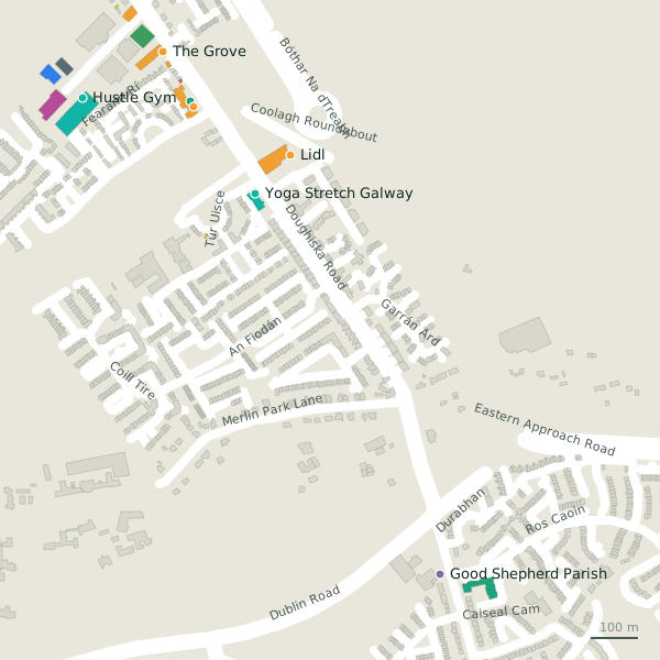
The street is drawn in black; buildings are coloured by what is in them. Drag to turn the model, tap a pin for the place.
Plan of the street
A walk along Doughiska Road
Start at the Coast Road end and walk towards Old Monivea Road: 3 convenience stores, 2 gyms, a church, a supermarket and a pharmacy share the 2.4 km. 1 of the 8 places on the street has opening hours on record, and it opens on Sundays. Buses stop on the street itself at 16 stops.
What is on Doughiska Road
3 convenience stores, 2 gyms, 1 churches, 1 supermarkets and 1 pharmacies, each with its own page.
Supermarkets · 4
- Coynes FoodmarketConvenience stores
- LidlSupermarkets · hours on record
- Tesco ExpressConvenience stores
- The GroveConvenience stores
Pharmacies · 1
- Merlin PharmacyPharmacies
Gyms and sport · 2
- Hustle GymGyms
Churches · 1
- Good Shepherd ParishChurches
Streets it joins
- An Castanresidential street
- An Fiodánresidential street
- An Sean Bhaileresidential street
- Caiseal Camresidential street
- Coast Roadregional road · 1 place
- Coill Aoibhinnresidential street
- Dublin Roadregional road · 24 places
- Duirlingresidential street
- Durabhanresidential street
- Fearann Ríresidential street · 9 places
- Garrán Ardresidential street
- Garrán Isealresidential street
- Inse Beagresidential street
- Maigh Rúaresidential street
- Merlin Commercial Parkservice road · 8 places
- Merlin Park Laneresidential street
- Old Monivea Roadlink road · 1 place
- Radharc An Chaisleáinresidential street
- Reileánresidential street
- Ros Caoinresidential street · 1 place
- Roscam Parkresidential street
- Saint Nicholas Parkresidential street
- School access roadresidential street
- Sraith Fhadaresidential street
- Túr Uisceresidential street
Questions people ask
Where is Doughiska Road?
How long is Doughiska Road?
What is on Doughiska Road?
Is there a bus stop on Doughiska Road?
Where can I park near Doughiska Road?
Geometry, names and places from OpenStreetMap, read on 2026-09-18. Length is the sum of the mapped segments carrying this name; distances are straight lines from the street's midpoint.