Upper Newcastle Road
Upper Newcastle Road is the R864, a residential street in Galway, 2.5 km north-west of Eyre Square. It runs 3.0 km from Snipe Avenue, about 37 minutes on foot end to end. It has 7 named places on the map: 2 convenience stores, cash machine, guest house and pub and more.
- Type
- Residential street (R864)
- Length
- 3.0 km of mapped road
- From Eyre Square
- 2.5 km north-west
- Joins
- An Bealach, Ard na Locha, Aughnacurra, Barr na Crannaí, Bóthar Na dTreabh, Bun Na Leaca, Chestnut Lane, Circular Road, Corrib Village, Dangan Court, Dangan Heights, Galway Business Park, Greenfields Road, Lakeview Hill, Lower Newcastle Road, Moyola Park, Snipe Avenue, The Westwood, Thomas Hynes Road
- Runs
- from Snipe Avenue
- Bus stops
- Greenfields Estate; St, Francis Home; St Francis Home; Moyola Park; Moyola Park; Corrib Village; Unnamed stop; Snipe Avenue 524401; Unnamed stop
- Parking
- 1 car park on the street: Pay and display car park
- Density
- 7 named places over 3.0 km, 0.2 per 100 m
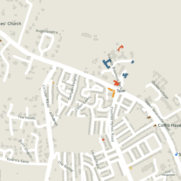
The street is drawn in black; buildings are coloured by what is in them. Drag to turn the model, tap a pin for the place.
Plan of the street
A walk along Upper Newcastle Road
Walking its length 2 convenience stores, a cash machine, a guest house, a pub, a church and a social service share the 3.0 km. 2 of the 7 places on the street have opening hours on record, and 1 of them open on Sundays. Buses stop on the street itself at 9 stops. There is parking on the street: Pay and display car park.
What is on Upper Newcastle Road
2 convenience stores, 1 cash machines, 1 guest houses, 1 pubs and 1 churches and more, each with its own page.
Pubs · 1
- Kelehans BarPubs
Doctors · 1
- St. Francis Primary & Daycare+353 91 861 100Social services
Banks · 1
- Bank of IrelandCash machines
Hotels · 1
- Corrib HavenGuest houses
Churches · 1
- Saint James' ChurchChurches
Streets it joins
- An Bealachlink road
- Ard na Locharesidential street
- Aughnacurraresidential street
- Barr na Crannaíresidential street
- Bóthar Na dTreabhnational road · 9 places
- Bun Na Leacaresidential street
- Chestnut Laneresidential street
- Circular Roadlink road · 2 places
- Corrib Villageresidential street · 3 places
- Dangan Courtresidential street
- Dangan Heightsresidential street
- Galway Business Parkservice road · 17 places
- Greenfields Roadresidential street
- Lakeview Hillresidential street
- Lower Newcastle Roadregional road · 10 places
- Moyola Parkresidential street
- Snipe Avenueresidential street
- The Westwoodresidential street
- Thomas Hynes Roadnational road · 3 places
Questions people ask
Where is Upper Newcastle Road?
How long is Upper Newcastle Road?
What is on Upper Newcastle Road?
Is there a bus stop on Upper Newcastle Road?
Where can I park near Upper Newcastle Road?
Geometry, names and places from OpenStreetMap, read on 2026-09-18. Length is the sum of the mapped segments carrying this name; distances are straight lines from the street's midpoint.