Spar
Spar is a convenience store on Upper Newcastle Road in Galway, County Galway, 2.4 km north-west of Eyre Square. DERI Café, Aerogen and Marvao Medical are within 135 m.
- Street
- Upper Newcastle Road
- From Eyre Square
- 2.4 km north-west
- Wheelchair
- Accessible
- Parking
- Unit 6 Visitor Car Park on Galway Business Park, 236 m away
- Bus stop
- Clifton Park (Bus Éireann), 133 m away
The map does not yet record a phone number or a website for Spar. Anyone can add them on OpenStreetMap; this page picks the change up at the next refresh.
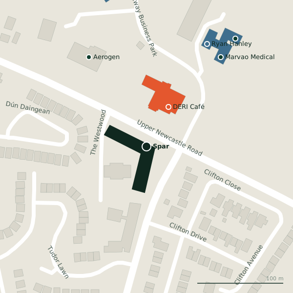
Plan of the surrounding 300 m
Getting to Spar
- By car
- Park at Unit 6 Visitor Car Park on Galway Business Park, 236 m away, free.
- By bus
- The nearest stop is Clifton Park, served by Bus Éireann, 133 m away, with a shelter.
- Directions from where you are
- Open the model above, tap the pin and choose “Directions here”; the route is drawn from your own position.
While you are there
1 place to eat or drink within 300 m: DERI Café (52 m).
Upper Newcastle Road itself has 7 named places on the map, and 1 car park along it.
It is open on Sundays (08:00-22:00), which not every place in the town is.
Opening hours
- Mon
- 06:30-22:00
- Tue
- 06:30-22:00
- Wed
- 06:30-22:00
- Thu
- 06:30-22:00
- Fri
- 06:30-22:00
- Sat
- 08:00-22:00
- Sun
- 08:00-22:00
As recorded on OpenStreetMap on 2026-09-18; bank holidays may differ.
Within a short walk
- DERI Café52 mCafés
- Aerogen123 mCompanies
- Marvao Medical135 mCompanies
- Ryan Hanley138 mEngineers
- Orbsen Therapeutics162 mCompanies
- Planet178 mCompanies
- HSE Enhanced Community Care Network201 mGovernment offices
- Western Management Centre208 mCompanies
Also on Upper Newcastle Road
- Bank of IrelandCash machines
- CentraConvenience stores
- Corrib HavenGuest houses
- Kelehans BarPubs
- Saint James' ChurchChurches
- St. Francis Primary & DaycareSocial services
Other convenience stores in Galway
- Bushypark Lawn476 mBushypark Lawn
- Day-Today553 mCorrib Village
- Laurel Stores827 mLaurel Park
- Centra1.1 kmUpper Newcastle Road
- Centra1.4 kmSeamus Quirke Road
- Student's Union Shop1.4 kmLower Newcastle Road
- Foodland1.5 kmOld Seamus Quirke Road
- Aroma Foods1.5 kmOld Seamus Quirke Road
Questions people ask
Where is Spar?
When is Spar open?
Are there other convenience stores nearby?
Source record: OpenStreetMap node/9283895509, read on 2026-09-18. The street is the mapped address where there is one, otherwise the nearest named road. Distances are straight lines.